ParkPointBeach.org is for beach goers at Duluth's Park Point Beach. The website operates between June 1 and October 1 and provides accurate and timely information to the public about water and beach conditions for Duluth's Park Point Beach on Lake Superior's south shore.
Rip Current Safety Toolkit. The National Oceanic and Atmospheric Administration (NOAA) and the U.S. Lifesaving Association (USLA) debuted a Rip Current Safety Toolkit July 19, 2021, to support the work of all beach and ocean safety advocates.
What is Park Point Beach?
Park Point Beach stretches along the south shore of Lake Superior for much of the seven-mile long sandbar called Minnesota Point that separates Lake Superior from the Port of Duluth-Superior. The Park Point Beach beach house, picnic area, and parking lot are located at the eastern end of the point. There's also a Minnesota Department of Natural Resources Scientific and Natural Area (SNA) at the far eastern end that has a magnificent old-growth pine forest.
Project description
The ParkPointBeach.org website is a product of the Twin Ports Rip Current Working Group and is designed to provide accurate and timely information to the public about the conditions on Park Point Beach, a seven-mile long Lake Superior sandbar in Duluth, Minnesota.
The site includes:
- Daily weather forecast
- Water and wave conditions
- Bacteria warnings
- UV index forecast
- Swim hazard (rip current) risk
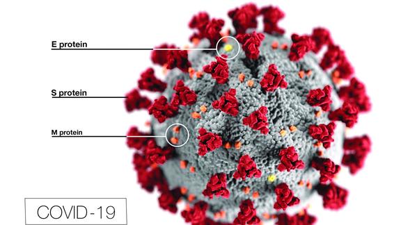
- COVID-19 notice
- Two beach cams
For beach goers who head to Park Point Beach without a device or means to check the beach forecast, there are a series of warning flags placed along the road leading to the Park Point Beach beach house.

- Low risk (green flag) indicates risk of rip currents is low. However, life-threatening rip currents often occur in the vicinity of jetties, reefs, and piers.
- Moderate risk (yellow flag) indicates that life-threatening rip currents are possible in the surf zone.
- High risk (red flag) indicates that life-threatening rip currents are likely in the surf zone.
The swim hazard risk gives details about rip currents and is taken directly from the National Weather Service surf zone forecast.
Project activities:
ParkPointBeach.org continues to provide real-time water temperature, wave heights, rip-current risk, UV index, bacteria warnings, weather, and more from June through September.
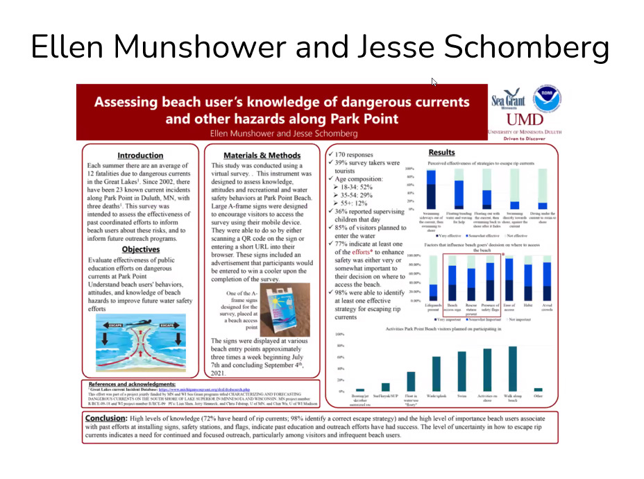
In summer 2021, the Twin Ports Rip Current Working Group conducted an online Park Point Beach visitor survey of people physically present at Duluth's Park Point Beach. The survey was designed to help guide and improve water safety and water safety messaging at Park Point Beach. A total of 182 survey responses were received and the Twin Ports Rip Current Working Group has been summarizing the results between September 2021 to present.
Two interesting survey findings thus far include:
- Over 20% of survey respondents indicated high risk of rip currents as a deciding factor to forgo the beach.
- Only 2% of survey respondents indicated that swimming directly to shore would be a very effective strategy for escaping a rip current. Most respondents (95%) recognized that swimming sideways away from a rip current would be a somewhat effective or very effective strategy for escaping a rip current.
In 2022, Minnesota Sea Grant Graduate Research Assistant, Ellen Munshower and Associate Director of Outreach; Coastal Communities Extension Educator, Jesse Schomberg won "Best Poster" at the 2022 St. Louis River Summit for their work on the Park Point Beach Survey conducted in summer 2021.
In 2020, the Twin Ports Rip Current Working Group replaced four safety stations that were damaged by large waves in 2018 and 2019. The safety stations have information signage, ring buoys, and ropes for use by beachgoers when they see someone in trouble in the water. Safety stations are located:
- Near the south pier, adjacent to the Duluth Aerial Lift Bridge
- At the 12th St. Tot Lot beach
- At the Lafayette Park beach
- At the Park Point Beach House
Why Minnesota Sea Grant?
ParkPointBeach.org supports Sea Grant's mission to enhance the practical use and conservation of coastal, marine and Great Lakes resources in order to create a sustainable economy and environment.
What have we done lately?
Participants & audience
The ParkPointBeach.org website is for everyone visiting Duluth's Park Point Beach.
Funding
ParkPointBeach.org is maintained and supported by Minnesota Sea Grant. Funding for its creation was made possible through support from the U.S. Environmental Protection Agency, Great Lakes Restoration Initiative, under Assistance Agreement No. GL-00E00632-0.
Research Projects
Partners
- City of Duluth, Minnesota, Fire Department, State/Local Government
- City of Duluth, Minnesota, State/Local Government
- Minnesota Department of Natural Resources, Lake Superior Coastal Program, State/Local Government
- U.S. Army Corps of Engineers, Duluth Area Office, Lake Superior Maritime Visitor Center, Federal Government
- City of Duluth, Minnesota, Parks and Recreation Department, State/Local Government
- National Weather Service, Forecast Office, Duluth, Minnesota, Federal Government
- University of Minnesota, Duluth, Natural Resources Research Institute, Academic Institution (College and University)
- University of Wisconsin, Madison, Academic Institution (College and University)
- Wisconsin Sea Grant, Sea Grant Programs