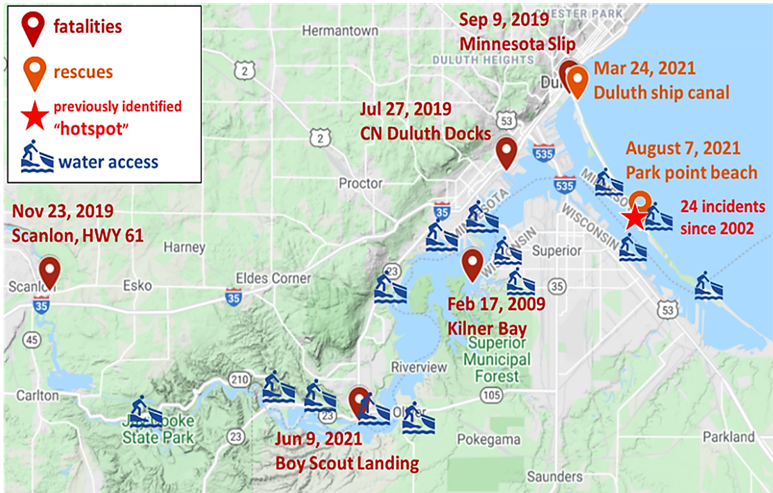
Locations of drowning and incidents in the St. Louis River Estuary and water access points (boating, beaches, campgrounds).
The goal of this project is to help prevent future drownings in the St. Louis River Estuary by characterizing, forecasting, and increasing public awareness of drowning hotspots, which are locations where drowning has occurred or that pose high drowning risks.
- Project start date: November 30, 2022
- Project end date: May 31, 2024
Two publicly available outputs were created as a result of this project:
- St. Louis River Estuary Nowcast/Forecast surface current model
- Drowning Incidents in the St. Louis River and Estuary ArcGIS story map
As a result of this project, Paddle Safe Twin Ports will be enhanced through the addition of three launch sites, which will be added to the website in summer 2024.
What is a drowning hotspot?
Drowning hotspots are locations where where drowning has occurred or that pose high drowning risks.
Features of potential river drowning mechanisms that pose drowning risks:
- Strainers: Undercut rocks and falling trees at river bends can allow water to flow through these obstructions, but can trap victims in/under the high flow of water (Kauffman, 2016).
- Emerged obstacles: Low-head dams or horizontal holes, known as “drowning machines,” can trap victims in recirculating flows (Kauffman, 2016).
- Strong currents: Can occur at river mouths or in shallow or restricted river channels and can sweep swimmers downstream. In estuaries, lake seiches or meteotsunamis can induce strong bidirectional flows with wave periods of minutes to hours, posing unexpected whirlpool vortices (Linares et al., 2018).
- Cold temperatures: Rivers fed by ice and snow can pose risks of hypothermia to people in water.
Project description
The goal of this project is to help prevent future drownings in the St. Louis River Estuary by characterizing, forecasting, and increasing public awareness of drowning hotspots, which are locations where drowning has occurred or that pose high drowning risks.
Objectives
- Characterize historical drowning locations, as well as potential drowning areas under current and future conditions.
- Forecast imminent drowning hotspots.
- Increase water safety knowledge among recreational users of the St. Louis River, and share data and tools with the local search and rescue community.
To address objective 1, the project team will compile locations of historical drowning and incidents in the St. Louis River Estuary and map potential drowning areas through field surveying along the St. Louis River stretch from the Scanlon Dam to the Duluth Harbor.
Characterization for each drowning hotspot will include:
- A historical drowning location or potential drowning area
- Water conditions (stage, flow, temperature) at the incident time
- River features (strainers, emerged obstacles, strong currents, cold temperatures)
- Accessibility (if it is a boat launch or a remote site)
- Safety measures (warning signs, railings, etc.)
To address objective 2, the project team will deploy 10 real-time water level and temperature monitoring stations with LoRaWAN (Long Range Wide Area Network) sensor technology to observe currents, water level, temperature, and weather conditions to develop models to assess drowning risk. The model will assimilate data from different data streams to assess risk under rapidly changing conditions.
Three of the 10 monitoring stations will be deployed in the St. Louis River at Mission Creek, Sargent Creek, and Miller Creek. The University of Wisconsin-Madison will deploy an additional seven stations plus an ADCP (acoustic doppler current profiler) to measure flows at Fond du Lac Dam. There are two existing U.S. Geological Survey gauges at the Scanlon Dam and Duluth Canal measuring streamflow, and a National Oceanic and Atmospheric Administration gauge in the Duluth Harbor measuring water level.
Imminent drowning hotspots in the St. Louis River Estuary will be predicted and forecasted by the University of Wisconsin-Madison using a state-of-the-art Integrated Nowcast/Forecast Operation System (INFOS) for COastal, Riverine, Estuarine (CORE) environment. In this project, the model domain of INFOS-CORE, previously developed by Principal Investigator Chin Wu, professor of civil and environmental engineering at the University of Wisconsin-Madison for defining and forecasting dangerous currents on Lake Superior's south shore, will be extended upstream into the St. Louis River at the Scanlon Dam.
To address objective 2 and 3, the project team will incorporate community science volunteers in this project to help expand data collection and to build a cohort of individuals well established in the local community who have knowledge of and are invested in this research.
Citizen science efforts will focus around two data collection activities:
- Volunteers will be recruited from the recreational paddlesport community (e.g., Northland Paddlers Alliance, North Shore SUP) to observe the condition of the real-time water quality monitoring stations and to measure surface water quality data that will be used to verify sensor measurements.
- Enlist kayakers to collect geospatial and surface water temperature data in the estuary. These citizen science kayak tours will provide high-frequency data to validate the model and provide a means to measure spatial and temporal (time) variability of temperatures.
Six core volunteer members will be trained to help record data observations at the water quality monitoring stations (i.e., LoRaWAN stations). The volunteers will be expected to paddle to their station a minimum of twice a month, with the opportunity to monitor more frequently if they so choose. Volunteers will paddle to one of the LoRaWAN stations where they will record or photograph the water level reading from the gauge. They will also measure temperature, conductivity and total dissolved solids using an electronic pen-style sensor supplied to them. An online form will be provided for uploading data, pictures and recording hours.
To address objective 3, Minnesota Sea Grant (MNSG) will lead outreach efforts for this project in two ways:
- Organizing and facilitating two stakeholder workshops.
- Improving information provided to recreational paddlers on the MNSG PaddleSafeTwinPorts.org website.
Background
Location-wise, reported drowning incidents have occurred in the St. Louis River from the Scanlon Dam to the river mouth at Duluth Canal and the estuary. Timing-wise, while a majority of the drowning incidents happened during the summer, a few drownings happened in the winter during cold water or ice-on conditions.
Different from coastal drowning, the past river drownings in the St. Louis River can be caused by low waves but complex flow and cold water conditions (Peden et al., 2015). To date, no effort has been paid to compile past drownings and incidents in the St. Louis River. Furthermore, no study has been conducted to reveal the vulnerability of locations and timings of drowning incidents in the St. Louis River. It remains unclear where the historical drownings occurred, when they occurred, and what factors led to them in the St. Louis River Estuary.
Previously, coastal drowning due to dangerous currents on the south shore of Lake Superior were investigated by the jointly funded Minnesota-Wisconsin Sea Grant project Defining and Forecasting Dangerous Currents on Lake Superior's South Shore, led by Lian Shen, professor of mechanical engineering and director of the St. Anthony Falls Laboratory at the University of Minnesota and Chin Wu, professor of civil and environmental engineering at the University of Wisconsin-Madison.
Outcomes of the project included real-time observations on beach images and wave-water temperature conditions near Park Point Beach. An Integrated Nowcast/Forecast Operation System (INFOS) was also successfully developed to forecast rip currents along the southwestern shore of Lake Superior, including three popular beaches in Duluth. Both observations and forecasts on the INFOS website are used by the National Weather Service Duluth and the local fire department and beach managers to generate coastal rip current watches, advisories, and warnings.
The current INFOS does not cover the St. Louis River, which experiences apparent river reverse flows due to interactions of storm discharges and lake seiches. The MNSG website PaddleSafeTwinPorts.org was created to address river water safety by targeting paddlers through the use of signages at recreation locations in the St. Louis River. Because drowning hotspots are not well identified, MNSG's Paddle Safe Twin Ports project team had difficulty placing signs at suitable locations for the larger recreational water user community. Due to the lack of understanding causes of river drownings, appropriate conditions that cause drownings (e.g., dangerous currents, cold temperatures) cannot be exhibited on the signage.
Why Minnesota Sea Grant?
The project Drowning Hotspots in the St. Louis River Estuary supports Sea Grant's mission to enhance the practical use and conservation of coastal, marine and Great Lakes resources in order to create a sustainable economy and environment.
What have we done lately?
- May 9, 2024: Minnesota Sea Grant and Wisconsin Sea Grant hosted the final project workshop for project participants and interested community members to learn about project results and outputs, including the St. Louis River Estuary current model generated through this research.
- March - April 2024: Efforts were underway to recruit our spring 2024 cohort of volunteers. Volunteers will help project researchers collect water quality data. Training is provided and volunteers can paddle on their own schedule. For more information or to sign up to volunteer, please contact Tiff Sprague.
- April 23, 2024: Minnesota Sea Grant will lead a table on water recreation safety in the St. Louis River Estuary during the St. Louis River Area of Concern annual celebration of progress. This event is being hosted by the St. Louis River Alliance.
- March 28, 2024: Duluth-Superior Metropolitan Interstate Council (Mike Wenholz, Principal Planner) hosted the 2024 first quarter meeting of the Harbor Safety Workgroup. Chris Filstrup provided an update on project progress, Kelsey Prihoda offered a sneak peak of the “Enjoy the St. Louis River Estuary Safely” fact sheet and companion webpage, and planning began for the final project workshop to be held on May 9.
- March 6 - 8, 2024: Members of the project team attended the 14th Annual St. Louis River Summit held at the University of Wisconsin-Superior to promote project work to date:
- A final draft of the “Enjoy the St. Louis River Estuary Safely” fact sheet was available at the Sea Grant table for review and comment.
- Citizen science opportunities for spring 2024 were promoted.
Chris Filstrup, project Principal Investigator, presented “Identifying and forecasting drowning hazards in the St. Louis River Estuary”
Participants & audience
Project audiences
- Local and visiting recreational users of the St. Louis River Estuary
- Local businesses in the water recreation and water sport industry
- Community groups
- City of Duluth, Minnesota, Parks and Recreation
- City of Superior, Wisconsin, Parks, Recreation and Forestry
Project partners
- St. Louis County, Rescue Squad
- City of Superior, Fire Department
- City of Duluth, Fire Department
- Wisconsin Sea Grant
- City of Duluth, Planning and Economic Development
- National Weather Service Forecast Office Duluth, Minnesota
- U.S. Coast Guard, Marine Safety Unit Duluth
- St. Louis River Alliance
- Duluth-Superior Metropolitan Interstate Council, Harbor Technical Advisory Committee, Navigational Subcommittee, Harbor Safety Workgroup
Project team
- Christopher Filstrup, applied limnologist and director, Central Analytical Lab, Natural Resources Research Institute, University of Minnesota Duluth.
- Kelsey Prihoda, Sea Grant Great Lakes transportation extension educator, Minnesota Sea Grant, University of Minnesota and University of Minnesota Duluth.
- Jerry Henneck, senior research scientist, Natural Resources Research Institute, University of Minnesota Duluth.
- Melody David-McKnight, sea kayak coordinator, Recreational Sports Outdoor Program, University of Minnesota Duluth.
- Tiffany Sprague, organizational development manager, Natural Resources Research Institute, University of Minnesota Duluth.
- Zach Wagner, researcher staff scientist, Natural Resources Research Institute, University of Minnesota Duluth.
Funding
Drowning Hotspots in the St. Louis River Estuary is funded by the Minnesota Department of Natural Resources, Lake Superior Coastal Program and the Wisconsin Department of Administration, Wisconsin Coastal Management Program. Award #: NA22NOS41990054. The project began November 30, 2022, and ends May 31, 2024.
Project history
2023
- November 2023 - March 2024: A water safety fact sheet ihas been developed for the St. Louis River Estuary in collaboration with the St. Louis River Area of Concern Coordinators, Wisconsin Sea Grant, and the Harbor Safety Workgroup with a goal of completion in April 2024.
- October 5, 2023: Chris Filstrup provided an update on project progress at the October 5 meeting of the Harbor Safety Workgroup.
- March 8 - 10, 2023: Through a tabling event, Minnesota Sea Grant and Wisconsin Sea Grant provided project information to attendees of the 2023 St. Louis River Summit. The map that resulted from the February 22 workshop was brought to the event, and attendees were encouraged to add to the data already collected and contribute to the body of knowledge on water safety incidents within the St. Louis River Estuary.
- February 22, 2023: Minnesota Sea Grant and Wisconsin Sea Grant hosted a workshop to bring together interested parties who wanted to learn more about this project, help researchers gather data on past water safety incidents on the St. Louis River, and find out how this project is involving and informing the community. Workshop attendees participated in a mapping exercise to gather data on water safety incidents that have occurred in the St. Louis River Estuary from 2000 to the present.